For an enhanced digital experience, read this story in the ezine.
Integrating sea-level rise and coastal threats into planning for beach parks in Maui County
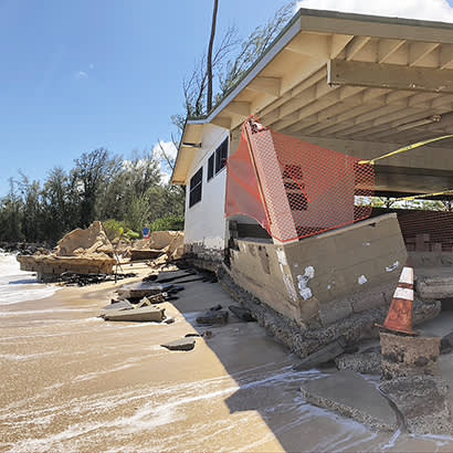
During the past several years, numerous beach parks in Maui County, Hawaii — which comprises four islands, of which three are populated — began to experience a significant loss of shoreline and the partial destruction of an open-air pavilion. Because these events were becoming more common, the County of Maui Department of Parks and Recreation (DPR), with the support of Director Karla Peters, initiated a project in 2020 to assess the vulnerability of its 65 beach parks. The department retained Tetra Tech, Inc., to work with staff to prepare the analysis and recommendations.
The project consists of four phases: (1) Identify the vulnerability rating for each park; (2) Prepare six general strategies; (3) Develop an interactive web-based app; and (4) Prepare more detailed recommendations for parks that are particularly vulnerable to coastal threats in the short term.
Methodology
Under the direction of Dr. Catherine Courtney, coastal scientist at Tetra Tech, Inc., the project started with an analysis of five conditions to assess the vulnerability of each beach park. These conditions included:
- Park area – How much of the park is exposed to sea-level rise
- Facilities – How many facilities and structures are affected by sea-level rise
- Access – How access to a park is affected by sea-level rise
- Timing – Approximately when a park will be affected by sea-level rise
- Beach migration – How much sand is available on land to support dune and beach migration
These factors were used to determine each park’s adaptation potential — low, medium or high. Each park also was assigned one of six general adaptation strategies, based on adaptation potential, which ranged from monitoring conditions to retreat/acquire land and relocate structures. Another strategy is to assess the viability of a park if access is uncertain.
The App
As part of the project, Tetra Tech, Inc., developed an interactive web-based app. It allows users to create and view maps of any county beach park, along with 17 data layers that can be turned on and off to create customized maps. The app can be accessed at tinyurl.com/44ea22ph.
Key Findings
The analysis generated a wealth of information about park vulnerability and adaptation responses, which varied by district. Most parks, about 60 percent, have a medium adaptation potential, while 20 percent have a high potential, and 20 percent have a low potential. Of the five park districts, the South District has the most beach parks, more than 80 percent of which have a medium or high adaptation potential. This is a stark difference from the West District, where about 45 percent of the parks have a low adaptation potential, which accounts for almost three-quarters of all parks with low potential.
Of the six adaptation strategies, “maintain facilities and monitor conditions” was recommended for 30 percent of the 65 parks. “Assess park viability based on future access” was the second most recommended strategy, which indicates that park access roads also are vulnerable to shoreline hazards. A key takeaway is that sea-level rise is a problem that affects the DPR and state and county departments, all of which will need to work together.
Decisions and Actions
With these findings, the DPR developed policies to guide department decisions and actions regarding planning, budgeting, construction and maintenance. These policies include: (1) Prioritize nature-based adaptation to restore coastal ecosystems; (2) Limit construction of new facilities exposed to 3.2 feet of sea-level rise; (3) Protect public safety by removing park structures damaged by coastal flooding and storms; and (4) Maintain undeveloped parkland outside hazard areas for future parks.
The DPR also identified critical priorities. These are: (1) Prepare adaptation plans and strategies for high-risk beach parks; (2) Integrate adaptation strategies with capital improvement project planning; (3) Prepare and apply cultural protocols when Native Hawaiian human remains are found; and (4) Coordinate with state and county agencies on adaptation planning. Given the complexity of adapting to climate change, the DPR has continued to stress that the time to plan and budget is now. Engaging the community in understanding vulnerability and adaptation strategies also is essential.
Though the study and its recommendations are almost complete, the DPR knows it will be dealing with sea-level rise and coastal threats for some time. There is no end or conclusion to this issue, but the department at least has a process, a planning tool it has been using for several months, and reliable data that can be updated. This will undoubtedly be a story that continues to evolve.
David Yamashita, Planner VI, is a Planner with the County of Maui Department of Parks and Recreation. Jen Maydan, Planner V, is a Planner with the County of Maui Department of Parks and Recreation.

