For an enhanced digital experience, read this story in the ezine.
During summer of 2016, Jefferson County (Colorado) Open Space (JCOS), through a partnership with Clear Creek County (Colorado) Open Space, opened the first segment of the Peaks to Plains (P2P) Trail in Clear Creek Canyon Park to visitors. This three-mile segment of trail — two miles in Jefferson County and one mile in Clear Creek County — is a 10-foot-wide, Americans with Disabilities Act-accessible, stained-concrete surface, with 500 feet in elevation gain, six new or improved creek access points, an expanded trailhead, and three bridges across Clear Creek. Each bridge is equipped with overlooks, so that visitors can enjoy the view out over the water. The trail is multiuse and welcomes a variety of recreational activities, from cycling and walking to fishing and gold panning.
In fall 2017, the final mile of the first segment of the P2P Trail opened, along with a developed recreation area and a new trailhead. The Big Easy trailhead and recreation area has a restroom, 54 parking spaces, fishing platforms over the water, picnic pavilions, a geology garden and a boardwalk in areas where vegetation needs to be protected. A new bridge also spans the creek, which connects to the Mayhem Gulch trailhead westward up the canyon.
Around this same time, the Great Outdoors Colorado (GOCO) Board awarded a $2 million grant to JCOS to fund a new, 1.75-mile segment of the P2P Trail in Clear Creek Canyon Park, which was referred to as the Gateway Segment. The grant was part of GOCO’s first round of funding for its new Connect Initiative, with $10 million in grants awarded to close critical gaps in trail networks across the state. More than 80 percent of people in Colorado recreate on trails, so increasing connectivity has long been a top priority for the state’s residents.
Project Details
JCOS started on the Gateway Segment of Clear Creek Canyon Park in 2018, with a contract for designing the east entrance of the canyon just outside of the City of Golden, Colorado. This 1.75-mile trail connects with downtown Golden along Clear Creek and continues west to Tunnel 1 along U.S. Route 6. The two new trailheads — one at the entrance to the canyon and one near Tunnel 1 — feature more than 170 parking spaces, permanent restrooms and shade structures. The parking area at the Gateway Segment of Clear Creek Canyon Park has the added features of a bike repair station, a bike rack with a metal frame crafted from the parts of cars salvaged from the canyon during construction, and a drinking fountain that includes a ground-level fountain for four-legged recreational companions.
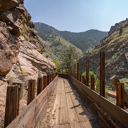
This project also included the first suspension bridge in Jefferson County. This pedestrian-only crossing of Clear Creek near Tunnel 1 connects hikers with the restored historic wooden flume of the Welch Ditch on the south side of the creek. Improvements and repairs were made to almost 1.5 miles of the Welch Ditch Trail, including 0.5 miles of the historic wooden flume. The wooden flume was originally constructed to transport water from Clear Creek through Golden to points east, beyond South Table Mountain Park, to help with farmland irrigation. At its height, the ditch helped irrigate 4,000 acres and supplied water to Golden and Jefferson County for 130 years. Once the ditch was decommissioned in 2001, it became closed to visitors for safety, but has reopened to the public and transformed to a trail, following structural improvements and repairs to this historical feature.
Much of the P2P Trail closely follows the rocky creek, and where possible, there has been an increase in sustainable water access, complete with improved rock staircases along the trail. The P2P Trail — and the Gateway Segment — honors the area’s mining history with materials and treatments like stained concrete, as well as weathered steel for the bridges and trail railings that are designed to help the trail blend in with the canyon.
This segment combined the GOCO Connect grant scope of 1.25 miles and the Colorado Department of Transportation (CDOT) Transportation Alternatives Program (TAP) funding of $850,650 for an additional 0.5 miles. In addition, Clear Creek County Open Space was awarded its CDOT TAP application request of $480,000 for the continuation of the P2P Trail further westward, following the alignment of the abandoned Colorado and Southern narrow gauge railway corridor.
The vision for the P2P Trail is a 65-mile trail of statewide significance that will serve the 3 million residents of the Denver metro area. This project relies upon 11 partnerships that are central to the success of this effort. The goal is that the P2P Trail will one day connect the South Platte River Trail north of Denver in Adams County to the headwaters of Clear Creek at Loveland Pass on the Continental Divide. Once completed, it will connect four counties and seven cities, with a total elevation gain of more than 6,700 feet.
This legacy trail project will offer visitors a truly quintessential Colorado experience. That is why it was chosen by Colorado’s governor as one of the state’s 16 highest priority trail projects as part of the Colorado the Beautiful Initiative.
Project complexities included steep canyon walls, narrow trail corridors, sensitive riparian areas, historic structures, access, impacts to visitors, and the Ute Ladies’ Tresses Orchid — a federally threatened species. Recognizing these significant design and construction challenges, the project received many awards in 2017, including the prestigious Honor Award from the American Council of Engineering Companies as one of the top 36 engineering projects in the country.
Chris Barker is Communications Supervisor at Jefferson County Open Space.

