


 When envisioning the San Antonio River, images of a bustling, urban tourist destination probably come to mind. Nature and recreation have traditionally played second fiddle to the commercial draw of the river in San Antonio. In fact, many people are surprised to learn that the San Antonio River is not an artificial channel created solely for tourism, but rather a natural river that extends more than 200 miles beyond the city. The San Antonio River Authority (SARA), the regional governmental agency charged with protecting the river, is trying to change perceptions through several innovative projects.
The Mission Reach Ecosystem Restoration and Recreation Project and SARA’s Nature Based Park Program seek to restore damaged ecosystems along the river, preserve functioning ecosystems, and encourage respect for and stewardship of the river through river recreation. The Mission Reach Project is a multi-agency effort to restore the ecosystem of eight miles of river and create recreation opportunities in a historically underserved urban area. The Nature Based Park Program includes the development of several new nature parks that focus on recreation in a near-pristine river ecosystem.
The Mission Reach – Reviving an Urban Ecosystem
For many years, the aesthetics and recreational amenities of the river beyond the River Walk attracted few tourists and recreation enthusiasts. During the 1960s, a massive channelization project was completed to manage flooding that plagued downtown San Antonio. This project straightened the river and removed vegetation from the flood plain to facilitate flood water conveyance. For decades, the channel has done its job of protecting downtown from devastating floods. However, it turned the river into little more than a drainage ditch with scarce aquatic and riparian habitat.
These conditions also created substantial barriers to river recreation. The historic River Walk contains many “street connections” where pedestrians can easily access the river. These connections were nonexistent elsewhere on the river. Furthermore, there were no trails to aid river recreation.
After years of careful planning, including extensive public input from area stakeholders, a concept for the Mission Reach was developed. In 2007, ground was broken on the eight-mile, $245 million project funded primarily by the Bexar County Visitor’s Tax. SARA serves as project manager during the construction phase. After completion in 2013, SARA will oversee operations and maintenance of the Mission Reach. Two miles of the project are already open to the public and under SARA’s care.
The project seeks to achieve several key goals:
Restoring the damaged ecosystem: The project is transforming eight miles of degraded river into a quality riparian and aquatic ecosystem. In total, approximately 334 acres of riparian ecosystem are being restored, with more than 60 native grass and wildflower species and more than 20,000 native trees and shrubs being planted. Maintenance of the project also includes the substantial task of removing non-native invasive plant species. During one week in August 2010, crews removed over three tons of weeds from the project. Clearly, managing non-native species on the Mission Reach will be a significant focus of long-term maintenance.
Fostering increased recreation on the river: The Mission Reach adds a variety of sorely needed recreation opportunities, including eight street connections, more than 15 miles of trails, many benches and picnic tables, and four pavilions. Pedestrians and cyclists have already begun to use the open portions of trail, and fishing is also increasing in popularity. Bird-watching is becoming more popular as bird species absent in the area for many years are returning. SARA hopes to introduce paddling in future phases of the project.
Restore the bonds between the historic San Antonio missions and the river: San Antonio is famous for the Alamo, but it is also home to four more historic Spanish Colonial missions situated in the National Park Service’s San Antonio Missions National Historical Park. During Spanish Colonial times, the missions were strategically located on and relied on the river. The Mission Reach Project is creating four “Mission Portals” that will visually tie the river to the missions through art installations and interpretive signage. These portals will also encourage visitors to wander up the trails to visit the missions and enjoy their unique cultural and recreational activities.
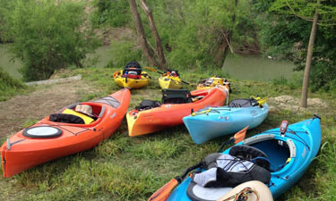
Rural Paddling Trails – Reconnecting People with their River
In Texas, navigable rivers and streams are publicly owned either by the State of Texas, or, rarely, by other public entities designated by the state legislature. Public ownership is good news for paddlers who want to experience rivers in the state. However, since 97 percent of land in Texas is privately owned, access can be a problem. The Texas Parks and Wildlife Department (TPWD) initiated the Texas Paddling Trail Program in 2006 to aid the public with river access. This effort builds partnerships between local and regional agencies and TPWD to establish sustainable paddling opportunities. The successful program has grown to include 27 designated inland paddling trails, as well as eight coastal paddling trails.
The San Antonio River Authority (SARA) is a proud participant in the Program, which fits one of SARA’s key thrusts: “Enhance community appreciation for and access to the San Antonio River and its tributaries.” SARA believes connecting people with the river’s positive attributes will foster a greater awareness of its roles in both the natural and built environment of south Texas, and will lead to increased support for its future stewardship.
Attaining Texas Paddling Trail designation in late 2006, the Goliad Paddling Trail resulted from SARA partnerships with the Texas Department of Transportation, County of Goliad, and Canoe Trail Goliad Inc. to establish three river access sites serving a 6.6-mile flat water paddling trail running from US Highway 59 to Goliad State Park.
This trail draws canoeists and kayakers from across Texas to paddle on their own or participate in annual spring and fall flotillas, one-day events organized with launching and loading assistance, free shuttle service, and discounts offered by Goliad merchants. Additionally, Goliad State Park has conducted summer kayaking lessons for area grade school children.
In early 2012, SARA attained Texas Paddling Trail designation for the 12.1-mile Saspamco Paddling Trail, another flat-water paddling trail that begins in southeast Bexar County and ends northwest of Floresville in Wilson County. Capitalizing on property availability at strategic locations over the past two years, SARA acquired a three-acre launch site at Loop 1604, a 22-acre mid-point site at County Road 125 in Wilson County, and a 98- acre take-out site at Farm to Market 775 in Wilson County. Each site has generous San Antonio River frontage as well as highway frontage, making them easily accessible to the public. SARA’s future plans call for development of other recreational and environmental education facilities within these three sites.
In addition to interpretive emphasis on environmental stewardship, a significant historical story will be told at these sites—particularly the take-out—because they lie along a segment of the El Camino Real de los Tejas National Historic Trail. SARA is currently part of a collaborative team led by National Park Service staff from the Recreational Trails and Conservation Assistance Program, National Trails’ Office, and the San Antonio Missions National Historical Park, working to conduct a feasibility study to connect existing and planned historical and recreational trails.
Take-away Lesson
Much like planning and implementing a successful paddling trip, there are some fundamental elements that resulted in the success of these public projects and programs.
• Partnerships and collaboration – gathering resources, knowledge, and strength.
• Planning and flexibility – anticipating all possibilities, adapting to change when needed.
• Landscape perspective – braiding together the multiple values of environmental stewardship, outdoor education, wellness activities, recreation, and economic development.
In conclusion, SARA believes that facilitating public access to and use of the San Antonio River will lead to enhanced public appreciation and long-term support for sustaining and enriching natural resources in the river’s watershed.
Dale Bransford, CPRP, CIG, is NRPA Park Resources Network Leader and Park Services Department Manager, San Antonio River Authority. Laura Waldrum, MPA, is Community Relations Coordinator for the San Antonio River Authority.